|
|
||||||||
|
|
| Atco Lake and Dam by David Wilcox |
|
ATCO LAKE AND DAM: ITS ORIGINS AND HISTORY David L. Wilcox, Historian
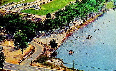
The dam at Atco Lake must be taken in the context of the lake. Without the lake it serves no purpose. On the other hand, the lake relies on a dam for its existence. The old concrete bridge at the dam has the date 1911 on it. The marker calls it “Atco Lake Bridge.” The lake obviously pre-dates 1911. Many people can say “I swam there” or fished or boated. Some remember the swimming beach and dance pavilion.
On George W. Hancock’s “Map of Atco,” the lake has approximately the same shape as at present or would if the water level increased. The Longacoming-Waterford Road (now Route 30) appears to cross the Hays Mill Creek on a bridge, rather than through a ford. The Clement map (1846) shows a lake of some size. On Thomas F. Gordon’s map of New Jersey (1828), Atco Lake appears smaller. Using Clement’s 1846 map as a basis, Boyer’s Old Mills places Marple’s Sawmill at the lake. Until recently, this book presented the earliest published reference to Marple’s Sawmill (Boyer 1962:61).
George Marple’s birth occurred about 1720, the son of Alice Northrop and Richard Marple of Moreland Manor, Philadelphia County, Pennsylvania (Cyclopedia 1921:158). Before his father’s death in 1747, George apparently traveled back and forth to Burlington County, New Jersey. He appeared in Burlington County during 1742 when he sued Joseph Thomas, shipwright, of Burlington, for £152 debt, which the said Thomas refused to pay (New Jersey Supreme Court Case File #27061). According to a Province of Pennsylvania marriage license dated 28 May 1744, Marple married, but the license does not include his wife’s name (Pennsylvania Archives. Second Series, Vol. II 1876:197).
Their son, George (Junior) was born about 1745 in either Burlington or Gloucester County. Other children followed: Susannah, born during 1747; Isaiah, born in 1750; Patience, born during 1757; and Mahlon, born in 1758 (Cyclopedia 1921:159). As late as 1751, documents record George Senior’s residence as “Northampton Township,” located in Burlington County (New Jersey Supreme Court Case file #45574).
By the time of a 24 February 1748 “Bill of Sale for a Slave” (Colonial Deed Book H 159) and two notices of a runaway slave, the following year (New Jersey Archives, First Series, Vol. XII, 548-49, 574-75), Marple operated from Goshen Neck in Burlington County along the Little Egg Harbor. At that time, it was part of Evesham Township, but is now (2003) in Shamong Township.
The principal occupation of the inhabitants of the interior, alongside mostly subsistence farming, was lumbering. Sawmills became a burgeoning industry in southern New Jersey due to the innumerable creeks providing a power source, and hard- and soft-wood forests. Typically, a millpond would be created with a leaky log or earthen dam. A millrace would draw water from the pond to give it five or more feet of head before driving an undershot waterwheel, which would provide the mechanical energy to run the mill. “[The] hauling of logs and other materials was accomplished by horse or ox teams drawing carts and sleds” (Wright 1979:4).
Marple purchased land at Goshen Neck on 29 June 1750 (Surveyor General’s Office Book E:212, 213, 214). The properties stretched from the north side of Atsion Creek, across the Little Egg Harbor or Mullica River, to the Mechescatauxin Creek. Three more deeds, dated 3 August 1750, stretched his holdings up the Little Egg Harbor and along the Atco Atco Branch, and to both sides of the Mechescatauxin (Surveyor General’s Office Book E:211, 213). By a deed of 3 November 1752, Marple purchased land on the “N[orther]ly side of Gosion [sic] Neck.” (Colonial Deed Book I-K:546) which suggests that, until then, he had leased the sawmill, but now had purchased it. On 4 February 1754, he bought along the “so[uth] side Equeatqua” (Surveyor General’s Office Book S-6:215). This was followed by a Sheriff’s sale, on 20 December 1754, of Goshen Neck to William Foster (Colonial Deed Book L:271).
Four years later, on 1 April 1758, Marple sold “property in Evesham, Burlington” to Abraham Inskeep (Colonial Deed Book A-G:238, 242; Book Y:17). It would appear that George Marple was now moving his operations to Gloucester County, as, in a complaint of trespass against him by Rebecca Scattergood, Marple’s bail bond describes him as “of Gloucester” (Gloucester County Document Collection, Bail Bonds, 1754, Scattergood vs. Marple).
Continuing his purchases across Gloucester County, he bought land west of the Great Egg Harbor Road on 28 April 1760, located near Longacoming (Surveyor General’s Office Book K:23). On 5 May 1760, he purchased land contiguous to his own and adjacent to Thomas Cole (Surveyor General’s Office Book K:21).
Settlers first arrived at Longacoming in 1714. “Some of [the settlers] lived a short distance from Long-A-Coming [sic] proper, but were a part of that settlement” (Prowell 1886:661). In his work on Berlin, local historian Charles Wright states, “In 1762, a road was laid out from Long-a-Coming [sic] to Chews Landing where boat transportation to Camden was available” (Wright 1979:5). Prowell confirms this information: “The products were hauled to Chews Landing, whence they were taken by boats to Philadelphia” (Prowell 1886:661). Based on the foregoing, Marple presumably supplied lumber for the wooden buildings of colonial Philadelphia.
Marple located his sawmill on the Longacoming side of Mechescatauxin (in various spellings) Branch (now called Hayes Mill Creek), a tributary of the Little Egg Harbor River (Boyer, 1962:map). He seems to have shifted his operations here, erecting the sawmill about 1763 on one of the parcels he purchased on 3 August 1750.
After the French and Indian War (1754-1763), New Jersey suffered serious economic conditions and had more indebtedness than any other colony. The British Parliament’s adoption of the Currency Act of 1764 “forbade the issue of paper money as legal tender in all the colonies and had deleterious effects in New Jersey. When the assembly met at Burlington in May 1765, there were evidences of depression. Debtors demanding relief sought measures to restrain lawyers from collecting debts and to prevent shopkeepers from giving credit of more than £6 to any one person. A kind of bankruptcy law was adopted to aid debtors with families” (Pomfret 1973:178-9).
In a bond dated 1 July 1764, “George Marpole [sic] of the Township of Waterford...Sawmill Man” agreed to pay Noah Garwood of Evesham Township £30 and 12 shillings if Marple failed to pay £15 and 6 shillings within a year. The Gloucester County court issued a Writ of Execution to arrest “George Marpole of the Township of Waterford, sawmillman” on 4 April 1765 at the instance of Garwood’s complaint for debt (Gloucester County Document Collection. Writs of Execution, 1765, Garwood vs. Marpole).
George Marpole, the father, died intestate in 1766. At the time of his “sudden and Unexpected” death, he had written his will but not signed it (Gloucester County Deed Book E:296-8; Book W:374). By the English laws of inheritance, called primogeniture, the eldest son inherited all of his father’s estate if a will did not exist. The inventory of the elder Marple’s estate, dated 10 September 1767, lists no sawmill equipment (Will 941H).
While George Jr. apparently took over the sawmill, equipment, and lands, two deeds show that he conceded to his father’s unsigned will that Isaiah and Mahlon receive certain parcels: On 22 September 1766, George Marple Jr. to Isaiah Marple for land in Gloucester Township, Gloucester County (Colonial Deed Book X:106); and, the same date, George Marple Jr. to Mahlon Marple for land described as “Branch of Little Egg Harbor River, Gloucester” (Colonial Deed Book X:108). The latter deed described the parcel of land as “Five hundred acres of Land adjoining the Lands of Samuel Scull” east and south of Longacoming.
In 1767 the younger George married Theodosia (Doey?) Rossell (Cyclopedia 1921:159). Although he worked as a sawyer, George did not have the same entrepreneurial abilities as his father, and he constantly overextended his finances.
A map of the original landowners at Longacoming in the possession of the Berlin (Marie Fleche Memorial) Library shows “Unappropriated lands” lying to the southeast of the village. On 6 February 1775, George signed a bond of obligation for debt to Robert Friend Price, in the amount of £101 (Gloucester County Documents Collection, Bonds, 1775, Marple/Price). On 3 May 1775 George Marple purchased 1500 acres of “Unappropriated lands” from Richard Penn, by Attorney, for £202 (Colonial Deed Book A-G:508). This land extended further into the interior and presumably beyond the Mechescatauxin, and at some time contained the site of Marple’s “Lower Mill.” Marple made his financial situation worse by signing additional bonds for debt to Joseph Ellis of Gloucester and Isaac Kay of Haddonfield (Gloucester County Documents Collection, Bonds, 1776, Marple/Ellis; 1778, Marple/Kay; 1780, Marpole/Ellis).
Kenn Stryker-Rodda’s Revolutionary Census of New Jersey lists George Marple in Waterford Township, Gloucester County in List II 1778-1780 (1972:138), but not List I for 1773 and 1774. During the Revolutionary War, Marple served with the men of “Captain Joseph Thorn’s Company (Probably Waterford Township)” who “were warned by First Lieutenant Samuel Matlack August 3, 1780, to prepare to march to Morristown” (Stewart, 1937:28).
George Marple appears in the tax lists for Waterford Township in July 1781 and February and August 1782 (Ratables. Gloucester County, Waterford Township, July 1781, February 1782, August 1782).
After the Revolution, New Jersey “was left with an uneven economy. With the currency in chaos, the farmers [and others], unable to pay their taxes, much less their debts, faced ruin” (Pomfret, 1973:288).
In March 1782, Joseph Ellis filed suit in court to recover his money. (Gloucester County Documents Collection, Bail Bonds, 1782, Ellis vs. Marple). Mary Edmond and John Glover filed additional court actions against Marple; and the court issued two separate writs for his arrest. (Gloucester County Documents Collection, Writs of Execution, 1782, Edmond vs. Marple, Glover vs. Marple).
With all of his accumulated debt, Marple moved to protect his brothers’ properties through issuing a quitclaim deed, dated 13 April 1782, for “[a]ll that Parcel of Land or Plantation now in Possession of ye said Isaih [sic] Marple” (Gloucester County Deed Book B:51). This indenture comprised the family farm by Big Timber Creek.
Robert Friend Price died late in 1776. The executors of his estate pursued George Marple Jr. for indebtedness once the outcome of the Revolutionary War was assured. Two bail bonds, at the instance of John Estaugh Hopkins and James Wilkins (Gloucester County Documents Collection, Bail Bonds, 1782, Hopkins & Wilkins vs. Marple) forced him to answer the summonses to the New Jersey Supreme Court, December term 1782. Judgment went against Marple and the court authorized the Sheriff of Gloucester County to seize and sell Marple’s property (New Jersey Supreme Court, Judgments and Process, Lib. O:213-215).
In July 1784, George Marple was counted as head of 8 white inhabitants and 1 slave in Gloucester County, Waterford Township (Cape May County & Gloucester County Inhabitants 1784:25). He appears in the Waterford Township tax lists for August of the same year (Ratables. Gloucester County, Waterford Township, August 1784) and for June-July 1785 (Ratables. Gloucester County, Waterford Township, December 1787; June-July 1789).
In a deed dated Mar. 30, 1786, George Marpole and wife Theodosia, with specific assurances that they had no claim on Mahlon, protected Mahlon’s property in Waterford Township near Longacoming (Gloucester County Deed Book W:374). George appears in the tax lists for Waterford Township for June 1786 (Ratables. Gloucester County, Waterford Township, December 1787 and July-August 1789). Although his accumulation of debt did not slow down, it appears Marple did pay his taxes.
As stated above, Joseph Ellis had obtained a judgment in March 1782, and John Estaugh Hopkins and James Wilkins, executors of Robert Friend Price’s estate, also had obtained judgments. Thomas Denny, the high Sheriff of Gloucester County, not finding enough goods and chattels to settle the debts, seized Marple’s lands and, on 21 October 1786, held a public sale at which Joseph Ellis acquired all of Marple’s property for £1000, as recorded in a 19 May 1787 deed (Gloucester County Deed Book O:292 et seq.; Book E:296-8).
The Waterford Township tax ratables list Marple for December 1787 and for July-August 1789 (Ratables. Gloucester County, Waterford Township, December 1787; July-August 1789).
By some means, on 19 December 1788, Marple convinced Thomas Hodgson to lend him money. True to form, Marple did not pay Hodgson back, causing his arrest in June of the following year (Gloucester County Documents Collection, Bonds, 1788, Marple/Hodgson; Bail Bonds, 1789, Hodgson vs. Marple).
Marple’s other creditors were dissatisfied with the 1786 Sheriff’s Sale to Ellis as it deprived them of recovering any part of their own debts. At the Newton Township home of Daniel Cooper, on 19 January 1790, Hodgson and Marple’s other creditors met and agreed to divide the property on equal terms, if Marple would transfer it to the assignees of Hodgson. It appears Marple also attended this meeting and agreed to the terms (Gloucester County Documents Collection, 1790, (4) Affidavits). Desiring redress of their grievance, the creditors met again on 8 February 1790 and, by letter of attorney from more than twenty of them, they authorized Samuel W. Harrison, Edward Gibbs Joseph Bolton, and John Clifford, as their attorneys, to use whatever means necessary for recovery of the estate for their benefit (Gloucester County Deed Book O:292 et seq.).
Harrison, Gibbs, Bolton, and Clifford, wanting as much of Marple’s estate as possible for their clients, first acquired from George Marple and Theodosia, his wife, all his real and personal estate by a deed of Trust dated 12 March 1790 (Gloucester County Deed Book O:292 et seq.). Chancery Court records for the Trustees of the Estate of George Marple (Harrison, Gibbs, Bolton, and Clifford, trustees) in account with the said estate begin 30 Mar 1790 (Chancery Court Register, 1795-1803). Second, the Trustees purchased from Joseph Ellis all the lands, sawmills, and premises which Ellis had purchased from the sheriff. By a deed dated 27 December 1790, the Trustees became owners of all of George Marple’s estate (Gloucester County Deed Book E:296-8; O:292 et seq.).
Hodgson apparently continued to be unhappy with Marple. On 1 September 1791, George Marple of Waterford Township, “in fear of his life or some bodily injury,” signed an affidavit against Hodgson to “keep the peace” (Gloucester County Documents Collection, Affidavits, 1791, Marple vs. Hodgson).
Finally, in the remarkably thorough deed dated 18 June 1792, Harrison, Gibbs, Bolton, and Clifford, trustees, sold the entire package, which included “a certain part of said tract of land being Marples old Homested [sic] place whereon the old upper Sawmill now stands,” to Martin Gibbs, Solomon Thomas, and Benjamin Atkinson, for £1500. This deed includes a full reiteration of the case, as excerpted above, and a complete survey of Marple’s lands in Waterford Township (Gloucester County Deed Book O:292 et seq.). The trustees transferred the 200 acres containing the sawmill by a later deed from to John Donnell of Waterford Township, Gloucester County, for $400. This deed also contains the whole history of the case and has also been used for the background information described above (Gloucester County Deed Book E:296-8).
By October 20, 1807, George and his wife still retained enough land in Gloucester Township to convey parcels to their daughters Susanna, Theodosia and Abigail (Gloucester County Deed Book W:164). The mill, by 1812, had passed from Donnell to Martin Gibbs and Company. George Marple died intestate on Feb. 19, 1813 in Gloucester Town Township. John Marple administered George’s estate which included a personal inventory valued at $91.75 (New Jersey Archives Vol. XLI 1949:249).
The name “Marple’s Mill” continued in use long after its sale to others, and the structure consistently served as a landmark for many years, especially for the surveying and laying out of roads in the southern reaches of the township.
Surveyors, laying out a road from the Borton Mill (Milford) Road in 1812, described the route as “standing in the line or road six chains from the North west corner of the saw mill known by the name of Marple’s big mill now the property of Martin Gibbs and Company” (Gloucester County Road Book B:102-3).
Similarly, the survey dated May 6, 1813, for what is now called the White Horse Pike and Burnt Mill Road begins “at a stake in the middle of Egg Harbor Road...in Longacoming then S 46° 30' E passing by stake in new road near the mill late Marples 277 ch[ain]s to a stake over the branch below said mill, then S 68° E 183 ch[ain]s” and then proceeding to the south and east (Gloucester County Road Book B:135).
Charles Boyer, writing in his work, Old Mills of Camden County, states, “Joseph Rogers and Samuel C. Champion offered a 350 acre tract of land for sale, including a corn mill, described as situated on the road leading from Long-a-coming (Berlin) to Marple’s Mill, about two miles from the former place” (The Herald and Gloucester Farmer, Jan. 22, 1823) (Boyer 1962:60). Boyer continues, “In 1823, a cedar swamp was offered for sale and described as located on the road from Long-a-coming to Marple’s Mill and adjoining the Burnt Mill Pond (The Herald and Gloucester Farmer, Jan. 29, 1823)” (Boyer 1962:62). Boyer states further, “About the time Thomas Richards acquired the land around Jackson for his glassworks [4600 acres in 1827], he also bought the old Marple Mill. As Richards’ Mill it is mentioned in a road return in 1828 (Gloucester Co. Road Book C:130) for a little road southward of Thomas Richards’ Mill to the Waterford Glassworks, thence crossing over Bates Mill Branch near his sawmill and thence to the Blue Anchor-Smith Tavern Road in[to] Galloway Township” (Boyer 1962:61). This latter road is the Old White Horse Pike and Spring Garden Road down to and beyond Waterford Works. Gordon’s Map of 1828 shows a lake on the appropriate creek.
On November 5, 1839, surveyors laid out a road “Beginning at a stake in the road leading from Longacoming to Batsto near Marples Mill, about two chains and twenty five links Northwest from the Bridge, over said Marples Mill Stream, and running north[east]” (Gloucester County Road Book D:59).
In 1844, just before the legislature erected Camden County out of Gloucester County, Delaware Township (comprising what are now Pennsauken, Cherry Hill, and Voorhees) was set off from Waterford Township. Clement’s 1846 Map of Camden County shows not just a millpond, but a sizable lake.
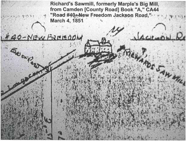
A drawing of Richards’ Sawmill exists on the 1851 survey for the New Freedom-Jackson Road (now Factory and Hayes Mill Roads). It shows a two-plus story building constructed in two parts: Marple’s Big Mill and the homestead (Camden County Road Book A:44). Clement’s Maps and Draughts (Vol. 2:32) has a survey map of the property divisions from Marple’s land from about this time period. It shows “Richards’ Mill formerly called Marple’s Big Mill” next to an appropriately labeled “Lake.”
In 1854, the Camden & Atlantic Railroad was laid through Waterford Township creating a focal point for what would become Atco. The railroad line south of the village cut off the (Old) White Horse Pike and Burnt Mill Road from Bates Mill (now Vineyard) Road and the road back to Longacoming. George Hancock laid the new community of “Atco” about 1866. His prospectus map prominently featured the lake, but a proposed North Lake Avenue ran across the site of Marple’s sawmill.
Marple’s sawmill was arguably the most complete and largest in size of the early sawmills in South Jersey, surviving for a hundred years from its colonial origins. In its time, it functioned as the southern extremity of the Longacoming settlement. Marple’s sawmill served as a landmark for road surveys as new transportation routes developed into the New Jersey Pines and beyond.
Although the sawmill passed from history more than 140 years ago, it left behind the newly-named, in the 1860s, “Atco Lake” as an already burgeoning wildlife habitat and a major part of the image of what the new community of Atco could become.
References:
Manuscript Sources
Anonymous Cape May County & Gloucester County Inhabitants 1784. Typescript. Gloucester County Historical Society, Woodbury, New Jersey.
Clement, John. Maps and Draughts, Vol. 2. Historical Society of Pennsylvania, Philadelphia, Pennsylvania.
Colonial Deeds. New Jersey State Archives, Trenton, New Jersey. Gloucester County Deed Book. Gloucester County Clerk’s Office, Woodbury, New Jersey. Gloucester County Document Collection. Gloucester County Historical Society, Woodbury, New Jersey.
Gloucester County Road Book. Gloucester County Clerk’s Office, Woodbury, New Jersey.
New Jersey Supreme Court Case Files. New Jersey State Archives, Trenton, New Jersey.
New Jersey Supreme Court, Judgments and Process, Lib. O. New Jersey State Archives, Trenton, New Jersey.
Ratables. Gloucester County. (microfilm) Gloucester County Historical Society, Woodbury, New Jersey.
Surveyor General’s Office Book. New Jersey State Archives, Trenton, New Jersey.
Wills. New Jersey Secretary of State Records. New Jersey State Archives, Trenton, New Jersey.
Maps Clement, John. 1846 Map of Camden County. John Clement Jr., Haddonfield, New Jersey. Camden County Historical Society Collection, Camden, New Jersey.
Gordon, Thomas [F.] 1828 Map of New Jersey. Thomas Gordon, Trenton, New Jersey. Camden County Historical Society Collection, Camden, New Jersey.
Hancock, George W. n.d. Map of Atco. (photocopy) n.p. Waterford Township Public Library Collection, Atco, New Jersey.
Printed Sources Boyer, Charles S. 1962 Old Mills of Camden County, New Jersey. Camden County Historical Society, Camden, New Jersey.
1921 Cyclopedia of New Jersey Biography: Memorial and Biographical. American Historical Society, New York City, New York.
1895 New Jersey Archives, First Series, Vol. XII. The Press Printing and Publishing Company, Paterson, New Jersey.
1949 New Jersey Archives, First Series, Vol. XLI. New Jersey Historical Society, Newark, New Jersey.
1876 Pennsylvania Archives. Second Series, Vol. II. Commonwealth of Pennsylvania, Harrisburg, Pennsylvania.
Pomfret, John E. 1973 Colonial New Jersey--A History. Scribner’s, New York City, New York.
Prowell, George R. 1886 The History of Camden County, New Jersey. L.J. Richards & Company, Philadelphia, Pennsylvania.
Stewart, Frank H. (ed.) 1937 Notes on Old Gloucester County Vol. 3. Frank H. Stewart, Woodbury, New Jersey.
Stryker-Rodda, Kenn 1972 Revolutionary Census of New Jersey. Polyanthos, Cottonport, Louisiana.
Wright, Charles W. 1979 The History of Berlin, New Jersey (Long-a-Coming). Privately printed. |
 |
Copyright 2002-2006 West Jersey History Project